While deciding on the most economic and fun option to explore California we stumbled on a great offer from Escape Campervans, for a roadtip experience. This was something we were thinking about for a while, so we started planning. The famous Highway one and Yosemite Park were quickly fixed as destinations. We initially had a few more in mind, like Death Valley or even Las Vegas, but quickly realized that we don't want to pack our shedule too much. Looking back at it this seems like the right decision.
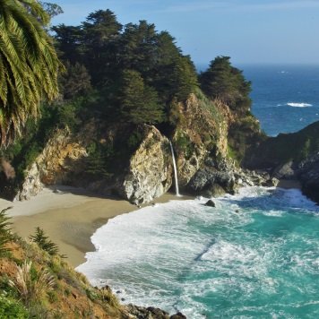
The picture you see here is from McWay Falls, where we stopped on Day 2 before Pfeiffer Beach, but let's start at the beginning...
Day 1
Los Angeles


We started the day with a long day at the The Getty, which is covered in another blog post. On the afternoon we finally set out to explore the coast.
Highway 1


The day ended at a nice camping place with a view over the ocean. We arrived quite late, so we didn't manage to take many pictures there.
Day 2

San Luis Obispo
Usually called SLO by the locals. Very laid back student-town. We spend a few hours to each lunch and explore it.


Morro Bay


Elephant Seal Vista Point


Big Sur
Now we entered Big Sur region, known for winding turns, seaside cliffs and views of the often-misty coastline. First stop were the McWay Falls, as described in the intro, then we continued to Pfeiffer Beach and ended the day at the Bixby Bridge.


Now the final task of the day was finding a camping stop for the night. It was dark now and we were getting tired. The only problem was, that national holidays just started, so all surrounding campsites were fully booked. At the second campsite we luckily got the secret tip: Camping close to the road next to Bixby Bridge, a bit further north. In case you are curious: This is the spot
Day 3


Because we didn't want to spend money on a hotel we decided to continue north that day and sleep in our Van again. Only: the problem from the day before still existed. All the campsites were full or had only ridiculously expensive spots left over. That's when we decided to continue driving to our first destination of the next day: Point Reyes. Sadly we didn't really find the campground there or any suitable spot on the way, so we ended up driving all the way to the parking spot of Point Reyes (see picture above with our van on it). What continued can only be described as one of the worst nights of our trip: Because we were so high up and close to the coast the wind was blowing full force outside against our van.
Day 4
We were awake early next morning, but not only because we couln't get much sleep. When I looked in the backmirror I saw the car of a National Park Service Ranger with its flashlight on. That was quite a shock for us. After we talked to him we learned that it was absolutely forbidden to camp in this area an we would have to pay a fee of $275 USD (about $350 CAD because of the horrible exchange rate). Luckily we ended up getting around paying it, but he told us that we were now on a blacklist and should make sure not to run into any trouble in a National Park again.
With that being over we started exploring Point Reyes. Apparently one of the windiest places in America (could've guessed that after last night) and also where the Point Reyes Station is located. The lighthouse is now obsolete with digital technologies, but the area is open to tourists.


After we finished exploring we left the coast and set our course inland towards Yosemite Vally. Because it was getting late and it is not always easy to find a camp spot in Yosemite Park we decided to stay at a small site not far from the entrance. As a funny coincidence we met another German who was camping with his girlfriend.

Day 5 - 7
Yosemite: See seperate blog post
Day 8
After leaving Yosemite we spent most of the day driving south.

We camped at a campground close to Pyramid Lake, which is not far from Los Angeles, so we could arrive there early next morning.
Day 9
We had the Campervan for another day, so we decided to use it to explore north LA a bit more. First stop was Hollywood, then we drove up to the Observatory to watch the sunset.

After that we had to leave the city again to find a campground. It took us some driving to find it, but we got rewarded with a great spot in the hills with a fireplace for our last grilled meal of the trip.

0 Comments: